Dec 30, 2019

Buck Creek Falls Washington

Buck Creek Falls Gifford Pinchot National Forest 

Buck Creek Falls is a small waterfall on Buck Creek, the source of White Salmon's water supply. A trail spur leads to the top of the falls, which spills into a lovely shaded pool in a basalt-rimmed bowl. Montia, alumroot and saxifrage adorn the rocks. The waterfalls is located in Gifford Pinchot National Forest and can be accessed by Trail #54 Buck Creek. 

Buck Creek Falls Washington
Buck Creek Water Falls
Washington Buck Creek Falls
Washington Buck Creek Waterfalls

Directions to Buck Creek Falls
Cross the Hood River Bridge from I-84 to White Salmon (toll $2). After crossing the bridge, turn left on Highway 14 heading west for Stevenson and Vancouver. In 1.5 miles, turn right onto Highway 141 Alt. for Trout Lake and the Mt. Adams Recreation Area.

In 2.2 miles, turn left onto Highway 141 for BZ Corner, Trout Lake and Glenwood. Drive 2 miles and make a left turn onto easy-to-miss Northwestern Lake Road.
Buck Creek Falls Loop Hike
Buck Creek Falls White Salmon River
Buck Creek Water Falls Washington
Go 0.4 miles, crossing the White Salmon River and come to a four-way junction and a large signboard detailing the Buck Creek Trail System. Keep straight here. The road becomes gravel and you drive 0.5 miles to the junction with Nestor Peak Road (Road N-1000). Stay on the B-1000 Road.

Continue on B-1000 aka Buck Creek Road to the Campground (milepost 3). This is a pull-in semicircle gravel area off the road with room for 6 vehicles. This is the Buck Creek Falls Loop Trailhead.

Dec 29, 2019

Antelope Canyon Fun Facts to Know

Interesting facts about Antelope Canyon in Page Arizona

Antelope Canyon is more than the most-visited slot canyon in the American southwest — it also offers travelers a rich history and exciting structure that few natural wonders can claim. Here are some fascinating facts about this beautiful canyon and piece of Navajo history.
Navajo Sandstones Antelope Canyon
Antelope Slot canyons

The canyon has a wave-like structure that gives it a unique look and, along with the canyon’s glorious light beams, makes Antelope the most-photographed slot canyon in the southwestern United States.

·         Antelope Canyon gets its name from local Navajo stories regarding antelopes that grazed along the canyon in the wintertime.
·         It is a slot canyon located on Navajo land east of Page, Arizona, United States.
·         The walls of the canyon rise 120 feet above the streambed.
·         It is sculpted into beautiful undulating curves and hollows that vary from one to 3 meters (3.2 to 9.8 feet) wide and up to 50 meters (164 feet) deep.
·         Antelope Canyon is referred to as one canyon, but is actually made up of two separate slot canyons: Upper Antelope, or The Crack, and Lower Antelope, or The Corkscrew. Both are breathtakingly beautiful and have their own unique geographical features, with the upper region providing tourists with the canyon’s famous light beams.
·         The canyon’s unique geography was created by water that rushed over its walls over many, many years.
·         The canyon is located in the LeChee Chapter of the Navajo Nation, near Page, Arizona.
·         A Guided tour is required to enter the canyon, a sacred monument of the Navajo people — it has been accessible by permit only since 1997 when it became a Navajo Tribal Park.
·         The entire length of the canyon’s entrance is at ground level, meaning visitors do not need to worry about any climbing.
·         The Upper Canyon is called “Tse’ bighanilini” by the Navajo people. This translates to “the place where water runs through rocks” in English. Upper Antelope is at around 4,000 feet elevation.
·         It is the most-photographed slot canyon in the American Southwest as well as the most visited.
·         The spring and summer months are more crowded to witness the gorgeous light beams, that shine directly down into the openings of the Antelope canyon, creating a supernatural appearance.
·         Today, Antelope Canyon is a popular location for photographers and sightseers, and a source of tourism business for the Navajo Nation. It has been accessible by permit only since 1997, when the Navajo Tribe made it a Navajo Tribal Park.
·         Flash flooding still occurs in the canyon and may, at times, result in up to several months of closing.
Antelope Canyon Fun Facts

Upper Antelope Canyon is more popular for two reasons. First, its entrance and entire length are at ground level, requiring no climbing. Second, beams or shafts of direct sunlight radiating down from openings at the top of the canyon are much more common in Upper than in Lower. Beams occur most often in the summer months, as they require the sun to be high in the sky. Winter colors are more muted. Summer months provide two types of lighting. Light beams start to peek into the canyon March 20 and disappear October 7 each year.

Dec 25, 2019

Lower Antelope Canyon Arizona

Antelope Canyon - The place where water runs through rocks

Antelope Canyon is geological formations which is more picturesque and a magnificent slot canyon just east of Page in Northern Arizona. With tall winding walls, it’s a monumental sandstone sculpture. A photographer’s dream location, the canyon is known for its wave-like structure, rocky orange curves, and the light beams that shine directly down into the openings of the canyon, creating a supernatural appearance.
Inside the Lower Antelope Canyon
Lower Antelope Canyon Arizona
Antelope Canyon in Navajo Tribal Park
It includes two separate, scenic slot canyon sections, referred to as Upper Antelope Canyon (or The Crack), and Lower Antelope Canyon (or The Corkscrew). Both canyons are located in Page Arizona, both offer spectacular views of twisting, swirling canyon walls, and both are comparatively priced.

Antelope Canyon Geology: It was formed by the erosion of Navajo Sandstone due to flash flooding and other sub-aerial processes. Rainwater, especially during monsoon season, runs into the extensive basin above the slot canyon sections, picking up speed and sand as it rushes into the narrow passageways. Over time the passageways eroded away, deepening the corridors and smoothing hard edges to form characteristic "flowing" shapes.
Antelope Canyon Navajo Tours
Flooding in the canyon still occurs. A flood occurred October 30, 2006 that lasted 36 hours, and caused the Tribal Park Authorities to close Lower Antelope Canyon for five months.

Lower Antelope Canyon
Lower Antelope Canyon, called Hazdistazí, or 'spiral rock arches' by the Navajo, is located several miles from Upper Antelope Canyon. Prior to the installation of metal stairways, visiting the canyon required climbing pre-installed ladders in certain areas.
Lower Antelope Canyon Page
Stairs leading out of Lower Antelope Canyon
Even following the installation of stairways, it is a more difficult hike than Upper Antelope. It is longer, narrower in places, and even footing is not available in all areas. Five flights of stairs of varying widths are currently available to aid in descent and ascent. At the end, the climb out requires flights of stairs. Additionally, sand continually falls from the crack above and can make the stairs slippery.
Antelope Canyon Arizona
Despite these limitations, Lower Antelope Canyon draws a considerable number of photographers, though casual sightseers are much less common than in the Upper canyon. Photography-only tours are available around midday when light is at its peak. Photographers cannot bring a tripod.
Antelope Canyon Page Arizona
The lower canyon is in the shape of a "V" and shallower than the Upper Antelope. Lighting is better in the early hours and late morning.

Dec 20, 2019

Horseshoe Bend Trail Arizona

Horseshoe Bend Hike Page Arizona

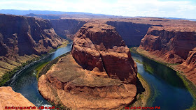
Horseshoe Bend is a sharp, curvy turn, bent into a horseshoe shape from which it gets its name. Horseshoe Bend has been featured as a unique landmark in Glen Canyon National Recreation Area, the located close to the Cities of Page AZ, and Kanab UT. It is crowded more just before sunset, as large groups of tourists make this hike down to see the overlook point.
Horseshoe Bend Page Arizona
Navajo Landscape Arizona
Glen Canyon National Recreation Area Page
An Entrenched Meander - Below the rim, the Colorado River makes a unique geological formation, a wide sweep around a sandstone escarpment. On its long downward journey to the sea, the river meandered, sometimes making wide bends, but always seeking the path of least resistance. Around 5 million years ago, the Colorado Plateau uplifted and the meandering rivers that crossed the ancient landscape were trapped in their beds. Over time, the rivers cut through the uplifted layers of sandstone. About nine miles downstream is where Grand Canyon National Park begins.

Here at Horseshoe Bend, the Colorado River created a roughly 1,000 ft (305 m) deep, 270º horseshoe-shaped bend in Glen Canyon.
The overlook is 4,200 feet (1,300 m) above sea level, and the Colorado River is at 3,200 feet (980 m) above sea level, making it a 1,000-foot (300 m) drop

The hike to the overlook - It is a gentle slope of 1.5 miles (2.4 km) round-trip over flat terrain. The trail is wide, easy for low-impact walkers, and accessible to wheelchairs. It has two shade stations along the way.
·         Route Type: Out and Back
·         Distance: 1.5 miles round trip
·         Starting Elevation: 4214 feet
·         Elevation of Peak: 4373 feet
·         Elevation Gain: 200 feet

As with any hike, be prepared with plenty of water, sturdy footwear, sunscreen, and other basic hiking essentials. Know that there is little shade along the Horseshoe Bend Trail. 
Horseshoe Bend Colorado River
Glen Canyon National Recreation Area
Horseshoe Bend Page

Warning
·         Avoid hiking during the hottest part of the day.
·         Take plenty of water in hot summer months of May-Aug also be prepared for the extreme heat.
·         If it too much hot in summer better avoid this hike, there is chances to get the Heatstroke or Hyperthermia. 

Horseshoe Bend Overlook Trail

Other Local Attractions in Page Arizona - Worth to Explore
·         Antelope Canyon
·         Lake Powell
·         Lone Rock Beach
·         Wahweap Bay and
·         Wahweap Overlook
·         Glen Canyon Dam and
·         Glen Canyon Dam Overlook Hike

Horseshoe Bend Overlook Hike
Horseshoe Bend Overlook Page

Directions to Horseshoe Bend : It is located 5 miles (8.0 km) downstream from the Glen Canyon Dam and Lake Powell within Glen Canyon National Recreation Area, about 4 miles (6.4 km) southwest of Page.

Dec 15, 2019

Horseshoe Bend Rock Geology

Horseshoe Bend Rock Formation - Page Arizona

Horseshoe Bend is a horseshoe-shaped incised meander of the Colorado River located near the town of Page, Arizona, United States.
Horseshoe Bend Rock Formation
Incised meander : Incised meanders are meanders which are particularly well developed and occur when a river's base level has fallen giving the river a large amount of vertical erosion power, allowing it to down-cut. There are two types of incised meanders, entrenched meanders and ingrown meanders.

How was horseshoe bend formed ? - Horseshoe Bend Geology
Horseshoe Bend was formed by water following its natural path of least resistance. The sheer Cliff walls are made of Navajo Sandstone, a particularly dense type of sandstone. In the process of erosion, the sandstone acted as a natural barrier, forcing the water to make a sharp bend in the river thorough softer rocks
Horseshoe Bend Geology Page Arizona
Navajo Landscape Page Arizona

Horseshoe Bend Overlook
It is accessible via hiking a 1.5-mile (2.4 km) round trip from a parking area just off U.S. Route 89.

Horseshoe Bend Fun Facts
·         Horseshoe-shaped incised meander in Colorado River located near the town of Page, Arizona
·         The rock walls of Horseshoe Bend contain a variety of minerals, among which are hematite, platinum and garnet.
·         The overlook is 4,200 feet (1,300 m) above sea level, and the Colorado River is at 3,200 feet (980 m) above sea level, making it a 1,000-foot (300 m) drop
·         The formation was created over the course of a billion years and was caused by the continual flow of water through the canyon walls.
·         The water in the Colorado River below is emerald green in summer and is cool enough to enjoy a refreshing swim, if you can make it down to the bottom.
·         Sunsets view of Horseshoe Bend is Breathtaking and must see the vibration of the colors
·         This is one of the most spectacular and most-photographed places in Arizona


Navajo sandstone cliffs Arizona
The water in the Colorado is slow moving, greenish blue in color and edged by thin strips of bright green vegetation - a striking contrast to the red-brown Navajo sandstone cliffs at either side. There are often several rafts and boats in view, making the short upstream journey from Lees Ferry; sandbanks and bushy areas along the river provide many stopping places.
Colorado River Horseshoe Bend
Horseshoe Bend Incised meander

Directions to Horseshoe Bend : From Page Arizona, reaching the Horseshoe Bend parking lot is a short, 10 minute drive south on Highway 89


Antelope Canyon Just 7 Miles away from Horseshoe Bend its one of the Natural Beauties must explore in Northern Arizona.

Dec 12, 2019

Velankanni Church

Basilica of Our Lady of Good Health in Velankanni

Velankanni is a small town in the South Indian state of Tamil Nadu. It is famous for its Roman Catholic Latin Rite Basilica of Our Lady of Good Health. It was built as per Gothic style of architecture of the Basilica, also known as the "Lourdes of the East", nearly 2 million pilgrims visit the Basilica every year. Three miracles have been reported around the area where the Basilica stands although the Holy See has not sanctified any of these.

Basilica of Our Lady of Good Health
Way to Veilankanni Church Pond
Velankanni Church
Morning Star Church Velankanni
Church of our Lady of Velankanni

The Basilica of Our Lady of Good Health, also known as Sanctuary of Our Lady of Vailankanni, is a Marian shrine located at the small town of Velankanni in Tamil Nadu, South India. The Roman Catholic Latin Rite Basilica is dedicated to Our Lady of Good Health. Devotion to Our Lady of Good Health of Vailankanni can be traced back to the mid-16th century, and is attributed to three separate miracles at the sites surrounding the Basilica.

Three miracles attributed to Our Lady of Good Health.

·         The apparition of Blessed Mary and the Christ Child to a slumbering shepherd boy,
·         The healing of a handicapped buttermilk vendor, and
·         The rescue of Portuguese sailors from a deadly sea storm.

Veilankanni Church Pond Walk Way
Basilica of Our Lady of Good Health Velankanni

 Main Places to see around the Velankanni
·         Basilica of Our Lady of Good Health in Velankanni
·         Veilankanni Church Pond
·         Morning Star Church Velankanni
·         Church of our Lady of Velankanni
·         Veilankanni - Adoration Center
·         Velankanni Beach

Velankanni Beach
Velankanni Basilica
Veilankanni  Basilica Extension

How to Reach : Velankanni is a Special Grade Panchayat Town in Nagapattinam district in the Indian state of Tamil Nadu. It lies on the Coromandel Coast of the Bay of Bengal, 350 km south of Chennai (Madras) and 12 km south of Nagapattinam. Frequent Bus services are available from Nagapattinam.

Dec 8, 2019

Thiruvanmiyur Beach Chennai

Thiruvanmiyur Beach ECR Chennai

Thiruvanmiyur beach is a popular attraction and the beach line is 1 km from East Coast Road. The Beach Walkers promenade is very popular with the local residents.

Chennai Thiruvanmiyur Beach
Thiruvanmiyur Beach Chennai
Thiruvanmiyur Beach ECR Chennai
Tiruvanmiyur Beach Chennai

Thiruvanmiyur Beach is located in the neighbourhood of Thiruvanmiyur in Chennai, Tiruvanmiyur Beach is one of the isolated and peaceful beaches of the city. Popular for beautiful sunrise and sunset views, the beach is mostly frequented by nature lovers, romantic couples or solitude seekers.

Dec 5, 2019

Valluvar Kottam Monument Chennai

Valluvar Kottam Monument Chennai

The Valluvar Kottam, located in Chennai, is one such historical monument which is dedicated to the well-known intellectual poet, philosopher and saint, Thiruvalluvar, who penned his well-known Thirukkural more than 2,000 years ago. All the 133 chapters of the Thirukkural comprise of 1330 verses.

Valluvar Kottam chariot
Valluvar Kottam chariot Chennai
Tiruvalluvar statue inside valluvar kottam chariot
Tiruvalluvar statue inside Valluvar Kottam chariot (வள்ளுவர் கோட்டம்)

Valluvar Kottam Chennai


Valluvar Kottam monument facts :
·         The architect of the memorial is South Indian traditional architect V. Ganapati Sthapati.
·         He is also the architect of the Thiruvalluvar Statue at Kanyakumari
·         Valluvar Kottam is dedicated to the classical Tamil poet philosopher Valluvar.
·         Valluvar Kottam is like a temple chariot (39 m high), inside which there is a huge stone effigy of the saint Thiruvalluvar.
·         A very unique feature of the Valluvar Kottam is that it stands baseless, without the support of any pillar.
·         The 1330 verses of the epic Thirukkural are engraved on the granite columns in the facade hall corridors, enclosing the vast auditorium.
·         The plan was executed by the then Chief Minister of Tamil Nadu M. Karunanidhi during the 1970s.
·         It was inaugurated in April 1976 by then President of India Fakhruddin Ali Ahmed.
·         It was Completed and inaugurated on 15 April 1976.
           
Valluvar Kottam Memorial
Valluvar Kottam Memorial Chennai
Valluvar Kottam Monument Chennai
Valluvar Kottam Monument

Valluvar Kottam also plays host to some of the most important exhibitions and events in the city. Handlooms and handicrafts are regularly hosted in the auditorium here which is an air-conditioned facility and is a good way to spend a few hours admiring the artistic beauty of both the what lays inside and outside.

Valluvar Kottam Park
Valluvar Kottam Stone Car

Directions: Valluvar Kottam is located at the intersection of the Kodambakkam High road and the Village road in Nungambakkam neighbourhood of Chennai.