Aug 28, 2019

Ramona Falls Mt Hood Oregon

Ramona Falls Mt. Hood National Forest Oregon

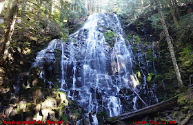
Ramona Falls is a waterfall on the upper Sandy River on the west side of Mount Hood Wilderness, Oregon, United States. It is located in forest along the Pacific Crest Trail at an elevation of 3,560 feet (1,090 m). The falls are about 120 feet (37 m) tall overall, consisting of a wall of cascades.

Ramona Falls Mount Hood Oregon
Ramona Falls upper Sandy River
Ramona Water Falls Oregon

Ramona Falls is 120-foot drapes across a stair-stepped cliff of columnar basalt. The very popular trail to the shady grotto of this Mount Hood cascade starts out in a mossy alder forest beside the Sandy River's bouldery outwash plain. A loop trail to the falls follows a portion of the Pacific Crest Trail.

·         Location: Clackamas County, Oregon, USA
·         Forest: Mount Hood Wilderness
·         Access: 7.1 Miles Hike Round trip
·         Waterfalls Type: Horsetail
·         Elevation: 3,560 feet
·         Total height: 120 feet (37 m)

Ramona Falls has such a lovely shape because it cascades over the remnants of a columnar basalt lava flow. When basalt lava cools slowly enough, it fractures into a hexagonal pattern perpendicular to the cooling surface. Later erosion has broken these basalt columns into a stair-stepped honeycomb.

Please Note:  Glacial River crossings on the flanks of Mt. Hood Wilderness do not have foot bridges. Hikers should be prepared to cross for dangerous river conditions.

Ramona WaterFalls Mount Hood Wilderness
Ramona Falls Mt Hood Oregon
Oregon Must see Scenic Waterfalls
Mt Hood Scenic Waterfalls Hike


Directions Ramona Falls Trail Head: 
From Portland, OR - turn north on Lolo Pass Road (Forest Road 18). Follow it four miles. Turn east (right) onto Forest Road 1825 and continue 0.6 miles, cross a bridge and then continue 1.7 miles to a road junction. Bear left at the junction onto Forest Road 1825-100 and drive 0.3 mile. Take a left onto Forest Road 1825-024 to a large open parking lot (0.2 mile) at the Ramona Falls trailhead.

Aug 25, 2019

Tamanawas Falls Snowshoe Hike Oregon

Tamanawas Falls Snowshoe Hike - Mt. Hood National Forest 

Tamanawas Falls was one of the more pleasing waterfalls to see as it featured a classic rectangular shape said to drop 150ft with a width of about 40ft.
Tamanawas Falls Trail-head
Tamanawas Falls Trail Oregon
Tamanawas Falls Trail #650
Cold Spring Creek Mt Hood
Tamanawas Falls in Winter

From the waterfalls parking lot at the East Fork - Tamanawas trailhead cross the East Fork of the Hood River at the bridge and turn right (north) on the East Fork Trail #650. The trail continues along the west bank of the river for half a mile to a junction with the Tamanawas Falls Trail #650A. Continue straight ahead on this trail (#650A).

Start point: Tamanawas Falls Trail-head
End Point: Tamanawas Falls
Trail Log: Trail Log
Hike Type: Out and Back
Distance: 3.4 miles
Elevation gain: 560 feet
Difficulty: Easy

Cross Cold Spring Creek at the bridge and turn left. Another quarter mile brings you to a junction with the Tamanawas Tie trail #650B. Turn left and cross the stream on a log bridge. The trail then follows the south bank a short distance.   After descending a series of log steps, it crosses back to the north bank. From here, the trail climbs through a talus slope and in a quarter, mile reaches the falls. 
East Fork Hood River in Winter
Tamanawas Falls Hike Oregon
Mt. Hood National Forest in Winter
Tamanawas Falls Snowshoe
Tamanawas Falls Snowshoe Hike

After visiting the falls, hikers may choose a different return route by taking the Tamanawas Tie trail. This trail climbs gently out of the canyon approximately 0.2 mile from the falls and after 0.5 mile reaches a junction with the Elk Meadows trail #645. Turn right and follow this trail downhill for 1.25 miles to a junction with the East Fork trail just above the Polallie trailhead parking area. If you have not arranged to be picked up here, turn right and follow the East Fork trail back to the Tamanawas Falls parking area to complete the five-mile loop.

Directions to Tamanawas Falls from Hood River: Travel south on Highway 35 for approximately 25 miles to the Tamanawas Falls trailhead parking area on the west side of the highway. The trailhead is 1/4 mile north of Sherwood Campground.

Aug 20, 2019

Tamanawas Falls Oregon

Tamanawas Falls Mt. Hood National Forest Oregon

Tamanawas Falls forms a broad curtain where Cold Spring Creek thunders over a 150’ lava cliff near the eastern base of Mount Hood. This hike along scenic Cold Spring Creek to the falls has been a traditional trek for families and is especially scenic in autumn, when cottonwood, Douglas and vine maple and western larch light up the forest in reds and golds. Tamanawas is Chinook Jargon for "spirit" or "spiritual guidance".

Tamanawas Falls Near Mt Hood
Frozen Tamanawas Falls Oregon
Frozen Tamanawas Falls Hood River
East Fork Hood River Oregon
Tamanawas Falls Oregon
Cold Spring Creek Mt Hood

Tamanawas Falls can be access from the East Fork Trail # 650, This trail is found on the east slope of Mount Hood and follows the Cold Spring Creek.  It is an ideal destination to cool off on a hot summer afternoon.  The falls are approximately 100 feet high and 40 feet wide.  The trail follows Cold Spring Creek and is shaded by large Douglas fir, cedar and a variety of trees and shrubs.

Tamanawas Falls in Winter
Oregon Tamanawas Falls


Directions to Tamanawas Falls from Hood River: Travel south on Highway 35 for approximately 25 miles to the Tamanawas Falls trailhead parking area on the west side of the highway. The trailhead is 1/4 mile north of Sherwood Campground.

Aug 18, 2019

Dry Creek Falls Hike Oregon

Dry Creek Falls Hike in Columbia River Gorge Oregon

Dry Creek Falls is accessed from the Pacific Crest Trail at Cascade Locks. This is a 4.4 mile out and back hike with only 710 feet in elevation gain, along the Pacific Crest Trail (PCT) that begins in Cascade Locks and meanders through beautiful forest to Herman Creek. Dry Creek Falls is a beautiful waterfall that often gets overlooked by hikers.
Bridge of the Gods Trail-head
Dry Creek Falls Hike Oregon
Oregon Dry Creek Falls Hike
Columbia River Gorge Scenic Waterfalls
Columbia River Gorge Oregon
To access the trail head, cross the road that leads to the Bridge of the Gods toll booth and start onto the PCT. The PCT parallels I-84.  There is an old orange safety fence here that encroaches the trail and is now more of a hazard than a help. In about 1/10 of a mile, you'll come to Moody Street as it crosses under the freeway. Walk the road uphill to the right for a bit, under the freeway. When the road angles left, go straight ahead on the gravel road a short distance to twin trail-heads. Altogether, the road walking here is about 100 yards. Take the trail to the left, which is the PCT. 

·         Start point: Bridge of the Gods Trail-head and
·         PCT Harvey Road Trail head
·         End point: Dry Creek Falls
·         Trail Log: Trail Log
·         Hike Type: Out and Back
·         Distance: 4.4 miles
·         Elevation gain: 725 feet
·         Difficulty: Easy

This heads gradually uphill, never too steep, through a pretty forest with dappled sun shining in. About one mile in, you'll come to a power line access road. Turn right here and follow the road a short distance under the power-lines to resume the trail. After the power line road, you'll come to a minor summit, and the trail begins a gradual descent to Dry Creek. Once you come to Dry Creek, the trail intersects another dirt road. Cross the road and Dry Creek on a wooden bridge, and continue on the PCT.  You can also head up to Dry Creek Falls by not crossing the bridge, but instead turning right at the road to head up about 2/10 of a mile to the falls. At the end of the road, there's a car turnaround and a fire pit.
Pacific Crest Trail (PCT) Oregon
Wildflowers Hike Oregon
Oregon Dry Creek Waterfalls Trail

Bridge of the Gods Trail-head or Toll Booth Park:  From I-84 take Exit #44/Cascade Locks. Follow the signs to Bridge of the Gods/Stevenson. Before crossing the bridge, you'll see a wooded park on your right.

Aug 15, 2019

Dry Creek Falls Oregon

Dry Creek Falls Columbia River Gorge Oregon

Dry Creek Falls, Oregon is a considerably taller waterfall than appears at first glance. Upon arriving at the base of the falls, the spirited 74-foot plunge of the creek spilling out of an extremely narrow canyon appears to be the extent of the falls. 
Dry Creek Falls
Oregon Dry Creek Falls Hike
Oregon Dry Creek Falls
However, tucked hidden in the canyon above the visible part of the falls actually lies another five (possibly more) drops which bring the cumulative height of the falls to around 230 feet. Unfortunately, the only way of reaching them is by rappelling into the canyon from above and climbing down the gorge with aid of ropes and wet-suits. 
Oregon Dry Creek WaterFalls

The city of Cascade Locks uses Dry Creek as its municipal water source. There is a small concrete dam that diverts a portion of the creek into a tunnel just below the falls.

The basalt amphitheater around the falls provides a great backdrop, and the basin does get remarkably green in the spring. Flowers are often seen growing around the base of the falls as well, and the falls should remain almost universally shaded outside the longest days of the year. It is one of the Scenic Waterfalls in Columbia River Gorge.

Columbia River Gorge Scenic Waterfalls
Columbia River Gorge Waterfalls
Dry Creek Falls Oregon

Dry Creek Falls is accessed from the Pacific Crest Trail at Cascade Locks. Park at the Pacific Crest Trail trail-head next to the Bridge of the Gods and follow the trail under Interstate 84. Under the highway the trail intersects a road, walk up the road about 300 feet to the continuation of the trail on the left. About 2 miles from the trail head the trail crosses Dry Creek. Just before crossing the creek, follow a gravel road uphill for another 1/4 mile to the falls.

Aug 10, 2019

Sahalie Falls Mount Hood Oregon

Sahalie Falls Mount Hood Oregon

Sahalie Falls is a pretty waterfall on the East Fork of the Hood River near Hood River Meadows. It is right at a wayside the old Mt. Hood Highway near Mt. Hood Meadows and Bennet Pass Trailhead. 
Sahale Falls Mount Hood Oregon
Bennett Pass Oregon
Government Camp Oregon
Mount Hood Meadows Oregon

Sahalie Falls / Sahale Falls is a lesser known waterfall on the SE side of Mt. Hood that plunges over 60 feet on the East Fork of the Hood River.  The waterfall is often hiked to as part of a loop hike in conjunction with the nearby Umbrella Falls.  Both waterfalls are easy to access during the summer from the Mt. Hood Meadows parking lots and on days in which the gates are open you can even drive to Sahale Falls.

Sahalie Falls Mount Hood Oregon
Old Mount Hood Scenic Byway
Old Mt Hood Scenic Byway
Sahale Falls Mt Hood Oregon

The falls veil 60 feet down the back of a verdant grotto, with additional drops of 4 feet and 10 feet immediately downstream. Though the falls are located at a high elevation on the slopes of Mount Hood, which guarantees a consistent amount of water in the river all year. The falls are viewed from a picturesque arch bridge dating back to the construction of the original Mount Hood Scenic Byway in the 1930s.

Directions to Sahalie Falls : It is found near Hood River Meadows Ski area off Highway 35 near Bennett Pass. Take Highway 26 east from Gresham to the junction of Highways 26 and 35, 2 1/4 miles east of Government Camp. Follow Highway 35 for 7.8 miles to the signed entrance to Hood River Meadows and turn left. After 1/2 mile, turn left again onto the Old Mount Hood Scenic Byway, which is signed for Sahale Falls, and follow the road to its end just before the bridge below the falls in another 3/4 mile.

Aug 8, 2019

Umbrella Falls Mount Hood Oregon

Umbrella Falls Hike Mount Hood Oregon

Umbrella Falls is a surprisingly significant waterfall found near the headwaters of the East Fork of the Hood River. After being diverted around one of the huge parking lots for the Mount Hood Meadows Ski area, the river veils 59 feet over a rough wall of reddish bedrock amid a forested meadow glade, a striking contrast to the sea of pavement just upstream.

Umbrella Falls Oregon
Mount Hood Meadows Ski area
Umbrella Falls Trail Mt Hood
Umbrella Falls Mount Hood Oregon

Because Umbrella Falls is located high in the drainage of the East Fork of the Hood River, the falls exhibit a significant variance in flow as the season progresses. Snow will linger in the basin well into July, but by September the amount of water flowing over the falls is greatly reduced.

Umbrella Falls is found near Mount Hood Meadows Ski area off Highway 35 near Bennett Pass. Take Highway 26 east from Gresham to the junction of Highways 26 and 35, 2 1/4 miles east of Government Camp. Follow Highway 35 for 6 1/2 miles and turn off at the signed entrance to Mount Hood Meadows. 
Mount Hood Meadows Oregon
Umbrella Falls Bennett Pass
Umbrella Falls Hike Mt Hood Oregon
Umbrella Falls Hike Mount Hood

Head uphill towards the ski area and after a mile and a half watch carefully for the trail on the right side of the road (the sign may or may not be standing). The easily graded trail leads through meadows to a bridge at the base of the falls in 1/4 mile.

Aug 5, 2019

Kings Mountain Hike Oregon

Kings Mountain summit Hike Oregon

King's Mountain is Located about an hour from Portland in the Tillamook State Forest (towards the Oregon Coast), It is a fun, moderate hike through the forest that ends with a great view of the surrounding hills. On a clear day There’s a view of Mount Hood and Mount Adams through the trees before we reach the summit.
Kings Mountain Trail Oregon
Trillium Blossoms in Kings Mountain Hike
Tillamook State Forest
Kings Mountain - Mt hood View
Elk Mountain and Kings Mountain are two popular hiking destinations in the Oregon Coast range. The trails are a little more rugged than typical Columbia River Gorge or Mount Hood trails. They are lower elevation than Mount Hood hikes so they are possible in the winter when Mount Hood trails are snowed in. There are two trail heads, the Elk Creek Trail-head and Kings Mountain Trailhead, off highway 6 between Portland and Tillamook. The Mazamas have adopted these trails, so it is well marked and well maintained.

·         Start point: Kings Mountain Trail-head
·         Trail : Trail Log
·         Distance: 5 miles round trip
·         Elevation gain: 2500 feet
·         Difficulty: Upper Moderate

The trail heads gradually up under alders and switchbacks at a view of a rushing creek. Then the path winds up steeply on a ridge before dropping and crossing the head of a small gully. The trail rises gradually. Sword fern dominates the under story. Head up a ridge with a rushing creek to the left and then walk on the level in Douglas-fir woods. From here on up it feels as if the hike gets steeper with every step – occasionally so steep that your footing slips a little. And just when you thought the incline couldn’t get any worse, you have to engage your hands to traverse a series of rock steps before the final push to the summit. Finally, the summit.
Tillamook State Forest Oregon
Kings Mountain summit Oregon
Mt Hood View from Kings Mountain
Kings Mountain summit Hike
Tillamook State Forest Hike

On a clear day, we can see Mt. Hood, an expansive swath of the Coast Range, and even the Pacific Ocean.  In the spring (late May to early June) Kings Mountain hike features an abundance of wildflowers including beargrass, paintbrush, penstemon, phlox, and the rare phantom orchid.

Kings Mountain Trail-Head Directions : From Portland, take highway 26 to highway 6. It's 49 miles west on highway 6 from the 26 junction. It's on the north side of the road and marked well.