Apr 29, 2019

Sprouting Horn Oregon Coast Hwy

Sprouting Horn and Thor's Well Oregon Coast 

Sprouting Horn Oregon : 
Sprouting Horn is another nearby natural attraction that arose near Cape Perpetua over a long period of time. A cave that developed along the coast, water and air gets funneled into the open space, building up pressure inside the cave. Once the pressure gets to be too much, the water spurts out, creating an ocean geyser that explodes upward at high tide, creating a mesmerizing view.
Sprouting Horn Oregon
Sprouting Horn Yachats
Thor's Well and the Spouting Horn

While hiking along the 0.75-mile round-trip Captain Cook Trail, you can find fascinating tidepools creatures at low tide, mountains of mussel shells left by generations of Alsea Indians who harvested them hundreds of years ago remains of a 1930s Civilian Conservation Corps camp and the spectacular Spouting Horn.

Good time To See :
Thor's Well or "Gate to Hell" at Cook's Chasm is a deep hole in the basalt rocks roughly around 20 feet deep. Moving upward water shoots to 20 feet high.

The best time to see these spectacular sites during high tides and storms, a period of time an hour before high tide to an hour after high tide.

Thor's Well – Yachats, Oregon
Sitting on the edge of the Oregon coast is what appears to be a gaping sinkhole that never seems to fill despite the unbroken stream of sea water that drains into it, but Thor's Well, as the natural wonder is known, is not bottomless, but it is very dangerous." - Atlas Obscura

Some call it a "gaping sinkhole," the "drainpipe of the Pacific" even a "gate to hell." It's known as a bucket list item for any thrill-seeking photographer, but a place that will swallow you whole if you venture too close...
Thors Well Oregon
Thor's Well Oregon
Yachats Spouting Horn
Located in the Cape Perpetua Scenic Area, just three miles south of Yachats, Thor's Well is a bowl-shaped hole carved out of the rough basalt shoreline.

At high tide, the waves roll underneath the bowl, filling it from the bottom until it bubbles out the top or bursts up in violent spray. The water then rolls back into the hole, making Thor's Well appear to fill and drain endlessly. It's fun to watch when the ocean is high, but return at low tide to see the mechanisms at work.

Oregon Spouting Horn
Oregon Sprouting Horn
Spouting Horn Oregon
Spouting Horn Yachats


Directions to Thor's Well: 
Just South of the Cape Perpetua Visitor Center in Cook's Chasm, Oregon. Park on the West side of Highway 101 to see it below.
To get to Thor's Well, park at the Cook's Chasm pull-out .3 miles south of the Cape Perpetua Visitor Center. You can see the hole from the viewpoints, or walk down the steps for a better look. You can also get to the spot via a trail connecting several points in the Cape Perpetua Scenic Area.

Apr 24, 2019

Cape Perpetua Overlook Oregon

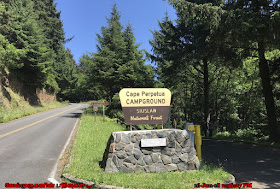
Cape Perpetua - Siuslaw National Forest Oregon

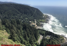
Cape Perpetua is a large forested headland projecting into the Pacific Ocean on the central Oregon Coast in Lincoln County, Oregon. The land is managed by the United States Forest Service as part of the Siuslaw National Forest.  
Cape Perpetua Headland viewpoint
Cape Perpetua Siuslaw National Forest
Cape Perpetua Overlook Oregon

Cape Perpetua is located about 2 miles (3.2 km) south of Yachats, Oregon, along U.S. Route 101. It is a typical Pacific Northwest headland, forming a high steep bluff above the ocean. At its highest point, Cape Perpetua rises to over 800 feet (240 m) above sea level. From its crest, an observer can see 70 miles (110 km) of Oregon coastline and as far as 37 miles (60 km) out to sea on a clear day.

Cape Perpetua Special Interest Area Located on the Pacific Coast of Oregon, the Special Interest Area is centered on the rugged Cape Perpetua headland, a bluff of volcanic basalt rising 800 feet above the Ocean. The 2,700-acre area includes a Visitor Center, 26 miles of maintained trails with access to the adjacent Cummins Creek Wilderness Area. 
Cape Perpetual Headland Viewpoint
Cape Perpetua Scenic Area Oregon
Cape Perpetual Bird Watching
Oregon Cape Perpetua Overlook

Cape Perpetua Scenic Area Lookout  
Towering 802 feet over the shoreline, the Cape Perpetua Headland is the highest viewpoint accessible by car on the Oregon Coast. On clear days, views extend 37 miles out to sea, and along 70 miles of coastline from Cape Foulweather to Cape Arago. The stone shelter was built in the 1930's by the CCC and served as a lookout for enemy ships and planes during World War II. 
Siuslaw National Forest Cape Perpetua
Siuslaw National Forest Oregon
Cape Perpetua Scenic Area Lookout
Cape Perpetua Scenic Area, encompassing 2,700 acres of coastal habitat, was set aside for unique ecological characteristics found where the temperate spruce rainforest transition to the sea. Early explorer Captain James Cook first observed the headland in 1778 and named it after Saint Perpetua. The scenic area offers 26 miles of trail, featuring old-growth forests, Indian shell middens, the Devils Churn, tidepools and stunning views.

Apr 20, 2019

Devils Churn Yachats Oregon

Devil's Churn Scenic Overlook Yachats Oregon

Devils Churn is a narrow inlet of the Pacific Ocean in Lincoln County, Oregon, United States, south of Yachats. It is located in the Siuslaw National Forest and is accessible via the Restless Waters trail from the Cape Perpetua Scenic Area visitor's center or the U.S. Route 101 overlook. Access to the trail requires a United States Forest Service pass.

Devil's Churn Viewpoint Oregon
Oregon Devil's Churn Scenic Overlook
Restless Waters Loop Trail Devils Churn
The Power of Devils Churn

The inlet developed over many thousands of years as wave action carved into the basalt shoreline, first forming a deep sea cave whose roof eventually collapsed. As the tide comes in it can throw spray several hundred feet into the air when the waves reach the end of the churn. Visitors are urged to be cautious when visiting the churn as it can be dangerous.

Located just north of the Cape Perpetua Visitor Center, here you can watch the crashing waves and the dramatic churning action of the ocean inside the wave carved inlet that we call Devils Churn. This deep chasm exposes the shoreline's volcanic history and shows the relentless, violent power of the ocean. The chasm likely started as a narrow fracture or collapsed lava tube in the volcanic bedrock. Over many thousands of years under the constant pounding force of the ocean waves it's now more than 80 feet wide where it opens at the ocean.
Devil's Churn Scenic Overlook
Restless Waters Loop Trail Oregon
Devils Churn Yachats

Restless Waters Loop Trail
This paved 0.4 mile National Recreation Trail hugs the coastline offering views of crashing waters, volcanic terraced tidepools and wind sculpted spruce. A wild place to see the winter surf as it explodes onto the terraces of volcanic rock.

Directions to Devils Churn Overlook
Cape Perpetua is about a 30 minute drive south of Newport on HWY 101

Apr 15, 2019

Otter Crest State Scenic Viewpoint

Otter Crest State Scenic Viewpoint Oregon 

Otter Crest State Scenic Viewpoint is a state park in the U.S. state of Oregon, administered by the Oregon Parks and Recreation Department. Going north on State Highway 101 the turnoff to the left comes up quickly and is easy to miss in the dense foliage. Taking it ones gets a view of Cape Foulweather.

Oregon 101 hwy Viewpoints
Oregon Cape Foulweather
Oregon Otter Crest State Scenic Viewpoint

To Soak in the view from 500' above the ocean on the breathtaking crescent sweep of white sandy beach stretching to the south. Cape Foulweather is stunning and inspirational with its picturesque panoramic views. This popular whale watching spot also provides a good view of the Devil's Punchbowl.

Cape Foulweather Oregon:
Cape Foulweather is a basalt outcropping 500 feet (150 m) above the Pacific Ocean on the central coastline of the U.S. state Oregon in Lincoln County south of Depoe Bay. The cape is notable as the first promontory on the northwest coast of New Albion (as the area was then known) to be sighted and named by Captain James Cook, while on his third voyage around the world.
Cape Foulweather Oregon
Oregon The Marine Reserve
Otter Crest State Scenic Viewpoint Oregon
Otter Crest State Scenic Viewpoint
Gull Rock Oregon

Gull Rock Oregon:
Gull Rock, Oregon is an island and is west of Finger Rock and southwest of Otter Crest Rest Area. Gull Rock is nearby to Devils Punchbowl State Park and Devils Punchbowl Arch.

Apr 12, 2019

Boiler Bay State Scenic Viewpoint

Boiler Bay State Wayside Scenic Viewpoint Depoe Bay

Boiler Bay State Scenic Viewpoint is a state park in the U.S. state of Oregon, administered by the Oregon Parks and Recreation Department. The park is one-mile (1.6 km) north of Depoe Bay, Oregon. 
Boiler Bay State  Park Oregon
Boiler Bay Scenic Viewpoint Depoe Bay
Boiler Bay State Scenic Viewpoint
Oregon Seabirds Watching Depoe Bay

Boiler Bay Viewpoint overlooks the small Boiler Bay. Boiler Bay was named after the vessel J. Marhoffer was run aground in the small bay—then known as Brigg's Landing—on May 18, 1910, after a fire spread throughout the engine room. Soon after, the burning 175-foot (53 m) schooner's fuel tanks exploded. Witnesses claim debris was launched nearly a half mile to a mile inland. The remains of the vessel were left in the bay, including her engine boiler. Today, the boiler can still be seen at extreme low tides.

 A miraculous and rugged, basalt-rimmed bay, Boiler Bay is a great place to watch wild surf action on the rocky spurs. This splendid panoramic viewpoint presents a good opportunity to see gray whales year round. 
Boiler Bay State Wayside Scenic Viewpoint
Gray Whale Watching Oregon
Oregon Depoe Bay Seabirds Watching
Oregon Boiler Bay State Scenic Viewpoint

Take your binoculars - this is one of the best sites in Oregon to see ocean-going birds (like shearwaters, jaegers, albatrosses, grebes, pelicans, loons, oystercatchers and murrelets). In 1910, an explosion sank the J. Marhoffer, and you can see the ship's boiler at low-tide.

Apr 8, 2019

Whittier 26 Glacier Tour Cruise

Alaska Prince William Sound - 26 Glacier Tour Cruise

The 26 Glacier Cruise departs from Whittier and travels through the pristine passageways and fjords found in Alaska’s Prince William Sound. Upon leaving Whittier, the vessel heads east out Passage Canal toward Egg Rocks or Perry Island in search of migratory Steller sea lions.
Surprise Glacier Inlet Viewpoint
Whittier 26 Glacier Tour Cruise
From there it proceeds to the very scenic area called Esther Passage where only small ships can navigate the waterway. High mountains protect this narrow channel from rough seas and winds. Many different animals call this area home; bald eagles are commonly seen fishing in the area along with occasional black bear sightings. It is not uncommon to see orca whales, humpback whales, sea lions, harbor seals, sea otters and a variety of birds in this narrow passage.

Highlights of 26 Glacier Cruise
·         Explore over 140 miles of Prince William Sound
·         Esther Passage, College Fjord, Surprise Glacier
·         Cruise route features 26 named glaciers and many others

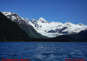
Esther Passage opens into College Fjord where the vessel turns north for a panoramic view of all the glaciers named after the Eastern Colleges during the Harriman Expedition. Next, cruise to Surprise Glacier and Barry Arm located in Harriman Fjord. The Captain plots a path through the ice-filled waters up to the front of the glacier so passengers can watch for massive chunks of ice calving into the sea.
Esther Passage Alaska
Glacier Tour Prince William Sound
Passage Canal Alaska
On the return trip to Whittier, the vessel will stop one more time at a kittiwake bird rookery that is located just across the bay from Whittier. Over 10,000 birds inhabit these rocky cliffs each summer laying eggs. They fish constantly in front of the rookery and then train the young hatchlings all the survival tips they will need before returning to fly south for the winter. The rookery is our last stop before returning to Whittier.
Prince William Sound Glacier Tour
Prince William Sound Tour wildlife
Surprise Glacier Alaska

26 GLACIERs we have seen around Whittier Alaska, in the cruise tour. 

Alaska Glacier Tour

Whittier Glacier

Billings Glacier

Tebenkof Glacier

Pigot Glacier

Cascade Glacier

Barnard Glacier

Holyoke Glacier

Wellesley Glacier

Vassar Glacier


Bryn Mawr Glacier

Smith Glacier (Alaska)

Harvard Glacier

Downer Glacier

Yale Glacier

Baby Glacier

Dartmouth Glacier

Williams Glacier

Amherst Glacier


Crescent Glacier

Ripon Glacier

Lawrence Glacier

Marquette Glacier

Beloit Glacier

Blackstone Glacier

Northland Glacier

Concordia Glacier


Alaska Glaciers Tour
Alaska 26 Glacier Tour Cruise

SUGGESTED DRIVING ITINERARY
Discover the glaciers of Prince William Sound on an easy day trip from Anchorage. Our afternoon cruise departures allow time for a leisurely morning in Anchorage before heading down the Seward Highway which is designated a National Scenic Byway. There are many photo opportunities along the way, so be sure to have your camera ready! At mile 79, turn onto Portage Glacier Road and continue to Whittier via the Anton Anderson Memorial Tunnel. After the cruise, the tunnel is open on the hour for your return to Anchorage in time for dinner and a chance to share stories about the glaciers and wildlife you saw.

9:00 AM Depart Anchorage and travel south on the Seward Highway to mile 79 and turn onto the Portage Glacier Road.
10:30 AM Tunnel entrance to Whittier, Alaska
11:00 AM Upon arrival in Whittier, collect your boarding cards and explore Whittier before parking.
11:45 AM Return to the pier for boarding. All guests are requested to be on board by 12:15 PM.
12:30 PM 26 Glacier Cruise departs
5:30 PM Return to the dock

The Anton Anderson Memorial Tunnel is open on the hour until 11:00 PM.