Mar 28, 2019

Portage Lake Alaska

Portage Lake Whittier Alaska

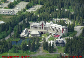
Portage Lake is a glacial lake in the Chugach National Forest of Alaska. It sits in a long, heavily glaciated valley, and abuts the calving face of Portage Glacier at its southern end. 
Portage Lake Alaska
Portage Lake Whittier Alaska
Alaska Portage Lake
Chugach National Forest Alaska
The western shore of Portage Lake is easily accessed via a large parking lot at the lakeside Begich Boggs Visitor Center, just off the Portage Glacier Highway. Portage Glacier Cruises operates a short glacier cruise, which takes visitors near the face of the glacier. Recreational boating in the lake was illegal in the past, due to rolling icebergs and the calving face of Portage Glacier at the far end of the lake, but is now legal, though proper precautions must be taken for the challenging conditions.

During winter and spring, the lake is a popular destination for cross-country skiing, kite skiing, mountain biking, skating, snowshoe running, and hiking.

Deep enough to submerge an 80-story building, the lake was carved out over thousands of years of glacial advances. While Salmon make their way into the lake, you may not see them due to the immense deposits of glacial silt. The silt also protects them from predators such as birds and larger fish. However, they eventually make their way to clearer waters. Look for dense blue icebergs from Portage Glacier blown to shore. 
Chugach National Forest
Whittier Portage Lake
Portage Glacier Alaska
Portage Lake Whittier

Directions to Portage Lake
From Anchorage head down the Seward Highway, go around 40 miles and turn left on to Portage Glacier Rd. The turn will be just past the train station as the highway makes a wide sweeping hook to the right. Head into Portage Lake there are good signs several miles down the road pointing to the visitors center and parking.

Mar 23, 2019

Rookery Falls Whittier Alaska

Rookery Falls – Whittier Alaska

Rookery Falls can be seen across the bay from the town of Whittier, one of many waterfalls dropping off of Learnard Glacier. It can be accessed up close from a kayak or one of the many cruise ships heading into Prince William Sound from Whittier. 
Kittiwake Rookery Falls Alaska
Alaska Waterfalls Rookery Falls
Alaska Rookery Falls Whittier

The waterfall is about 200 feet (61 m) high and drains a small lake perched above the cliffs. A large rookery adjacent to the falls has about 6,000 breeding Black Legged Kittiwakes, in addition to Glaucous-winged Gulls and Pigeon Guillemots. This is one of the largest kittiwake colonies in Alaska and is accessible by boat. It is named as Rookery Falls because of the kittiwake rookery here. It is an unofficial name. 
Rookery Falls Learnard Glacier
Rookery Falls Whittier Alaska
Rookery Falls Whittier
Whittier Rookery Falls

The very interesting thing about Rookery Falls is the kittiwake rookery located here. You will see hundreds of these birds flying and nesting around this waterfall. It is very interesting and unique. 

·         Waterfalls Name : Kittiwake Rookery Falls
·         Height: 200 ft.
·         Access:   By boat  
·         Elevation: 600 ft.
·         Season: May-Oct
·         Location: Whittier, Prince William Sound, Valdez Cordova County

Directions to Rookery Falls : It is located on the northern shore of Passage Canal, about 1.2 miles (1.9 km) northwest of Whittier, Alaska.

Mar 20, 2019

Kenai Mountains National Heritage Area

Kenai Mountains – Turnagain Arm National Heritage Area

The Kenai Mountains are a mountain range in the U.S. state of Alaska. They extend 192 km (120 mi) northeast from the southern end of the Kenai Peninsula to the Chugach Mountains, and have an average elevation of 3,000 to 5,000 feet.
Kenai Mountains – Turnagain Arm National Heritage Area
Chugach Mountains Range Alaska
The Harding and Sargent Icefields, as well as the many glaciers that originate from them, derive in the Kenai Mountains. Several prime fish-producing rivers, including the Kenai River and the Russian River, also flow from the mountains. 

The name "Kenai" was first published by Constantin Grewingk in 1849, who obtained his information from I. G. Wosnesenski's account of a voyage to the area in 1842. The Kenai Indian's name for the mountain range is "Truuli."
Kenai Lake Alaska

Kenai Mountains – Turnagain Arm National Heritage Area
The Kenai Mountains-Turnagain Arm National Heritage Area (KMTA NHA) encompasses a distinctive landscape of mountains, lakes, rivers, glaciers, and fjords. The area is comprised of north-south road, rail, and trail corridors from Bird to Seward and includes the communities of Girdwood, Portage, and Moose Pass. To the west, the area includes Cooper Landing, Sunrise, and Hope. To the east lie Portage, Whittier, and the wild waters of Prince William Sound.
Kenai Fjords National Park
Portage Glacier Road Alaska
Portage Lake Alaska
Kennai National Heritage Area Alaska
Kenai Mountains Range Alaska
Kenai Mountains – Turnagain Arm National Heritage Area is a federally designated National Heritage Area in the U.S. state of Alaska. The heritage area extends across the northern part of the Kenai Peninsula, immediately to the north and east of Kenai Fjords National Park. The designation recognizes the area's unique cultural, scenic and historical features and provides a unified organization for promotion of the area's attractions.

The Kenai Mountains – Turnagain Arm National Heritage Area (KMTA) includes the road corridor between Seward and Hope and Whittier, from Resurrection Bay in the south to the Turnagain Arm of the Cook Inlet in the north. It includes portions of Chugach National Forest, the Iditarod Trail network, the Alaska Railroad and the Seward Highway.

Mar 15, 2019

Turnagain Arm Gulf of Alaska

Turnagain Arm in Seward Scenic Highway 

Turnagain Arm is a waterway into the northwestern part of the Gulf of Alaska. It is one of two narrow branches at the north end of Cook Inlet, the other being Knik Arm. Turnagain is subject to climate extremes and large tide ranges.
Scenic Seward Hwy Attractions
Alaska Seward Highway
Alaska Turnagain Arm
The Turnagain Arm is a special body of water. Housed between the Chugach Mountains and the Kenai Mountains, the inlet is home to the rare and ill-named bore tide. This fascinating phenomenon, where the incoming seawater forms a six to ten foot wall as it returns at high tide, only occurs before and after the extreme tidal conditions of the new or full moon.

The 45-minute drive from Anchorage to Girdwood along the Turnagain Arm of Cook Inlet is one of the world's great drives, ranking right up there with Italy's Amalfi Drive and the highway along the Rhine south of Coblenz. The Seward Highway linking Anchorage and Seward is a National Forest Scenic Byway and one of 15 roads in the United States that has been designated as an "All-American Road."
Beluga Point Seward Highway Milepost 110
Turnagain Arm Alaska
Turnagain Arm Bore Tide
From beginning to end there are dramatic views of mountain scenery and the inlet. Turnagain Arm's bore tide is the second highest in North America, second only to the tide in Canada's Bay of Fundy. Beluga Point, a few miles further along, offers dramatic views of the Inlet and owes its name to the beluga whales that can sometimes be sighted from there.

Beluga Point Alaska
Beluga Point Site is an archaeological location along Turnagain Arm of Cook Inlet, near Seward Highway Milepost 110, south of Anchorage, in the U.S. state of Alaska. It was added to the National Register of Historic Places on March 30, 1978.
Turnagain Arm Gulf of Alaska
Turnagain Arm in Seward Scenic Highway
Beluga Point Alaska
Artifacts of the area are evidence of early human habitation. Beluga Point North 1 artifacts are 8,000–10,000 years old and believed to be evidence of the oldest habitation in Anchorage municipality. Various other artifacts at Beluga Point South 1 and 2 (BPS1 and BPS2) are believed to be 3,500 to 4,000 years old, while some newer ones are dated at 600 to 800 years old.

Beluga Point is also a wildlife viewing area under the jurisdiction of the Alaska Department of Fish and Game. Beluga whales can be sighted seasonally July through August as hundreds of the cetaceans visit Cook Inlet to feed on the Pacific salmon run.

Mar 10, 2019

Mt Alyeska Ski Resort Alaska

Mt Alyeska Ski Resort in Girdwood Alaska

Alyeska Resort is a ski resort in Girdwood, Alaska, approximately 27 miles (44 km) from the city of Anchorage. Mount Alyeska is part of the Chugach mountain range and the Alyeska Resort is the largest ski area in the state. It includes the mountaintop Mt. Alyeska Roundhouse, which is listed on the National Register of Historic Places.
Alyeska Ski Resort and Hotel Alyeska
Mt Alyeska Ski Resort
Alyeska Resort is truly a playground for all levels of skiers and riders. Offering 1,610 skiable acres, 76 named trails and over 669" of snow annually, Alyeska lives up to its reputation as steep and deep. In the summer, Alyeska Resort is the gateway to the Chugach Mountains, offering a peek into the vastness and wild nature of the amazing range, home to numerous wildlife and flora species.
Chugach Mountain Range Alaska
Chugach State Park wilderness
Mount Alyeska Turnagain Arm View
Girdwood Mt Alyeska

Alyeska Aerial Tram
The Alyeska Aerial Tram is a three-to-seven minute scenic ride from The Hotel Alyeska to 2,300 ft in elevation and the top of Mt. Alyeska. From the Tram, you can see for miles in all directions – including views of the Turnagain Arm, up to seven “hanging” glaciers, and endless peaks deep into the Chugach Mountain range.
Alyeska Aerial Tram Ride
Mt Alyeska Ski Resort Girdwood
Girdwood Mt Alyeska Aerial Tram
Don’t forget to look down! In the summer months, moose and bear sightings are common in the aerial tram rides. At the Mountain Station, there is an observation deck providing even more breath-taking panoramic views of majestic mountains, hanging glaciers, sparkling streams, towering spruce, and an array of wildlife. The observation deck is a perfect place to enjoy a relaxed lunch or beautiful evening sunset. Telescopes are also available along the deck.

Directions to Mt Alyeska Resort : From Anchorage, take the Seward Highway south for about 36 miles. Turn right at Girdwood and follow the signs for Alyeska resort. From the point where you turn right you can see breathtaking Mount Alyeska and its many ski runs. You can either start at the bottom of the ski area and hike up or ride the aerial tramway to about halfway up the mountain.

Mar 8, 2019

Potter Marsh Bird Sanctuary Alaska

Wildlife Viewing at Potter Marsh Anchorage


Potter Marsh, at the southern end of the Anchorage Coastal Wildlife Refuge, is an ideal break from Anchorage for birders and other wildlife viewers. From the Seward Highway just before the left turn into the Potter Marsh parking lot, you are treated to a stunning view of Turnagain Arm. A wooden boardwalk winds 1,550 feet from the parking area through the marsh and across watery openings and sedges, perfect habitat for a rich variety of birds. 
Arctic tern Alaska
Anchorage Coastal Wildlife Refuge
Alaska Coastal Wildlife Refuge

From late April through September, Canada geese, northern pin-tails, canvasback ducks, red-necked phalaropes, horned and red-necked grebes, and northern harriers use this wetland. Look for eagle nests in the cottonwoods near the base of the bluff using binoculars or a spotting scope. Eagles have a sharp sense of sight and can see at least four times better than people, enabling them to detect movements of small animals like hares from a mile away. When eagles soar overhead, they are scanning open areas for prey.

Notable Species in Potter Marsh Birds Sanctuary
·         Chinook salmon
·         Coho salmon
·         Beaver
·         Moose
·         Muskrat
·         Trumpeter swan
·         Northern pintail
·         Green-winged teal
·         Canvasback
·         Red-necked grebe
·         Northern harrier
·         Sandhill crane
·         Arctic tern
·         Red-winged blackbird

From May to August, gulls, Arctic terns, shorebirds such as yellow-legs, and occasionally trumpeter swans are present during spring and fall migration. 
Moose Viewing Area Alaska
Potter Marsh Bird Sanctuary Alaska
Potter Marsh Bird Sanctuary
Potter Marsh Board Walk

In addition to birds, look for slow movement and a v-shaped wake in the waters of the marsh, signs of muskrats swimming past. Their small brownish heads peek just above the water as they meander in and out of the wetland's open areas.

Moose also frequent the marsh year-round. May and June are good times to see these large ungulates standing in the marsh foraging for new growth.

About halfway along the boardwalk, Rabbit Creek flows underneath and provides a good spot to see spawning chinook, coho, or humpback salmon from May to August, depending on the species. Spot their bright red bodies swimming in the creek.

With its nearly panoramic view of Turnagain arm, Potter Marsh, buffered by spruce, cottonwoods and alders, is one of the most accessible and scenic wildlife viewing areas in Anchorage. 
Potter Marsh Wetland Anchorage
Potter Marsh Wetlands Anchorage
Seward Highway Attractions
Wildlife Viewing at Potter Marsh Anchorage Area
Potter Marsh Board Walk Anchorage

Located at the southern end of the Anchorage Coastal Wildlife Refuge, the 540-acre Potter Marsh offers easy access to nature, with a 460-meter-long wheelchair-accessible wooden boardwalk.

Driving Direction to Potter Marsh Bird Sanctuary : Seward Highway milepost 117.4. Take the signed Potter Marsh exit to the east (toward the mountains), then follow the road south to a parking lot by the boardwalk. For other views, there are two highway pullouts off Seward Highway along Potters Marsh between mileposts 116 and 117 and a parking area off Potter Valley Road at the south end of the marsh at milepost 115.6. Parking is limited to these pullouts.