May 28, 2018

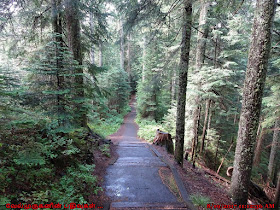
Forest Park Firelane 7 Hike

Firelane 7 Springville Road Loop Hike

Forest Park is a public municipal park in the Tualatin Mountains west of downtown Portland, Oregon, United States. Stretching for more than 8 miles (13 km) on hillsides overlooking the Willamette River, it is one of the country's largest urban forest reserves.
Firelane 7 Trailhead
Forest Park Firelane 7 Hike
Forest Park Firelane Hike
In the central and northern sections of vast Forest Park, numerous fire lanes and old road tracks run from east to west down the slope of the Tualatin Hills. Before the Wildwood Trail was built through here, these were the principal avenues of access. This loop uses a Firelane 7 on the way down the slope and Springville Road on the way back, both routes making use of ridge lines where you won't see a lot of other visitors. Springville Road is an old wagon road that Tualatin Valley farmers used to haul their produce up and over the hills to the Willamette River. In between Firelane 7 and Springville, you'll hike along the more popular Wildwood Trail, following contours in and out of gullies in secondary forest. Look for forest wildflowers in spring and early summer and mushrooms in the fall.

Hike Description
Walk down Springville Road through a green gate. In about 30 yards, Firelane 7 peels off to the right. The firelanes and roads in Forest Park are also used by mountain bikers, so keep alert on this section of the hike. Big-leaf maple, red alder, sword fern, salal, western red-cedar, Oregon grape, Douglas-fir, grand fir and a few hemlock saplings make up the woodland here. Come to the Hardesty Trail-Firelane 7 Junction and keep right. The trail rises briefly and passes the junction with the Trillium Trail, which offers a shortcut to the Wildwood Trail. To complete this loop, however, stay on Firelane 7 in an avenue of alders and maples and then descend again. Keep right at the junction with the Ridge Trail. The wide firelane levels and rises. Alders dominate here. Reach the junction with Firelane 7A and stay right. This is also called the Oil Line Road (part of Firelane 7). There are more evergreens on this section. Warning signs declare a petroleum pipeline. Arrive at the Wildwood Trail-Firelane 7 Junction and go left.
Forest Park Hike
Forest Park Hiking Trails
Portland Forest Park Oregon
Wildwood Trail  Oregon
Alders, maples, cascara saplings and old stumps make up the woodland. The forest becomes young hemlocks under Douglas-firs and maples. Sword fern, holly, and Oregon grape make up the understory. Then enter deciduous groves of maple and alder with thickets of salmonberry along the draws. Keep straight at the junction with Firelane 7A. There are glimpses of the industrial area far below and always the sounds of traffic and trains. The woods are very open in the winter on this section as many of the trees are deciduous. Pass a pit next to the trail. Head into a deep draw with cedars and drooping vine maples on a maidenhair-lined trail. Cross a seasonal creek and then the trail heads gently up. Pass the junction with the Ridge Trail. Descend on an old road bed and pass through a grove of hemlock and cedar, crossing a seasonal creek on a footbridge. Then hike under more hemlocks and cedars to arrive at the Wildwood-Hardesty Trail Junction, where you go right.
Wildwood Trail Portland
Firelane 7 Hiking in Portland
Descend and cross a creek; then pass the "Big Stump", a huge cedar stump with springboard notches: this tree was brought down over 100 years ago. The Hardesty is a wide, packed trail that loses altitude rather quickly. A creek runs on your right. We come to the junction with Leif Erikson Drive, which is very popular with runners and bikers, and go left at Milepost 9. Cedar, hemlock and Douglas-fir predominate down here. Sword fern and inside-out flower verge the road. Ivy crawls high up many of the conifers and carpets the forest floor. On the left are some cement steps from a house that once stood here, a reminder that, beginning in 1914, Leif Erikson Drive (then Hillside Drive) was platted out as a subdivision. A damaged, feathery branched Arizona cypress, snapped off about ten feet up, still survives here. Come to a Forest Park map sign and head up Springville Road to the left. Note the occasional Pacific yew amongst the other conifers. Soon come to the junction with the Wildwood Trail and cross it. Pass an orange gate on your left and keep rising to the junction with Firelane 7, where you go right through the green gate to parking. Source: Oregon Hikers

·        Start point: Springville Road Trailhead
·        Hike Type: Loop
·        Distance: 4.9 miles
·        Elevation gain: 1120 feet
·        Difficulty: Easy
·        Seasons: All year
·        Features: Birding, Fall Colors, Wildflowers, Wildlife
·        This trail connects with other trails: Wildwood Trail, Gasline Trail, Northwest Springville Road, Ridge Trail, Old Firelane 7 and Trillium Trail.

How to Reach:
Northwest Firelane 7 Road is a hiking trail in Portland, Oregon. It is within Forest Park. Springville Road Trailhead has Small parking lot and turn around which provides access to Springville Road and Firelane 7. Springville is open to pedestrians, cyclists, and equestrians; FL7 is open only to pedestrians and equestrians. Also nearby are the Hardesty, Trillium, and Ridge Trails which are pedestrian access only.

May 23, 2018

Larch Mountain Crater Hike

Larch Mountain Crater Hike in Columbia Gorge

Larch Mountain is second only to Mount Hood on the Portland skyline. It's distinctive profile can be seen from the entire city. What's less known is that like Mt. Hood, Larch Mountain is a volcanic peak with a crater of its own, albeit very old and eroded. The original hard rock surface of the crater has been eroded into soil that now supports forests and flowery meadows.
Larch Mountain Columbia River Gorge
Larch Mountain Trail TR441
Larch Mountain Columbia Gorge trail
This hike starts at the Larch Mountain Trailhead. The Larch Mountain Trail, #441, starts at the southwest corner of the parking lot. This section is one of the few Columbia Gorge trails open to mountain bikes, although it doesn't seem to see a lot of use. You'll start by passing through an old, mostly abandoned campground. The trail then drops down somewhat steeply through a dense, view blocking forest. You'll cross a closed road and a large campsite. Two miles down, you'll turn right on to the Multnomah Creek Way Trail #444.

The path continues dropping down to a log bridge over Multnomah Creek 2/10 of a mile from the trail junction. Just across the bridge, you'll find Multnomah Creek Spur Trail #446. Stay to the right and continue on Trail #444 traveling upstream. The trail, now deep in the old crater, passes through a marshy meadow filled with shooting stars and marsh marigolds in the spring. This was once a lake, but centuries of natural sediments have filled it. Sherrard Point towers over this area. The trail switchbacks up the crater wall to an old logging railroad grade. The trail follows the relatively level abandoned grade for about a mile to a junction with Oneonta Trail #424.
Columbia Gorge trails - Larch Mountain
Larch Mountain hike in Columbia River Gorge
Turn right here and head up Trail #424 for almost a mile to Larch Mountain Road. Turn right and hike up the road for 3/10 of a mile to your car
·         Start point: Larch Mountain Trailhead
·         Trail Log: Trail Log
·         Distance: 6.9 miles loop
·         Elevation gain: 1476 feet
·         Difficulty: Moderate

Sherrard Point View Point: Sherrard Point is the exposed volcanic conduit on the top of Larch Mountain. Once the site of a fire lookout, the pinnacle now hosts a fenced observation platform with views of five major volcanic peaks (Rainier, Adams, St Helens, Hood and Jefferson) as well as the Columbia River and scores of lesser summits. It's reachable via a 0.3 mile long paved path (with stairs) or as the climax of a 7.2 mile trek up from the Columbia River at Multnomah Falls.
Sherrard Point Hike Trail
Sherrard View Point in Larch Mountain
Sherrard Point in Larch Mountain
Larch Mountain Hiking Team

Larch Mountain Crater Loop Trail
This paved trail starts at the Larch Mountain Picnic Area and leads to the scenic, ancient volcanic summit of Larch Mountain. There are 100 steps in the trail leading up to a mountain-identifier viewpoint.


May 21, 2018

Shepperds Dell Falls

Shepperds Dell Falls Columbia River Gorge, Oregon

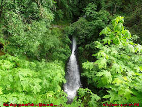
Shepperds Dell Falls is One of the most beautiful and located in Historic Columbia River Hwy, Young Creek Bridge crosses the canyon here, but you can't see it unless you step down from the car and take the short trail to the falls.
Shepperds Dell Falls
Shepperd's Dell State Park
In 1915, a local dairy farmer named George Shepperd gave all that he had (this tract of land) to the City of Portland as a memorial to his wife. Today, thousands of visitors along the Historic Columbia River Highway visit this beautiful spot, with its roaring waterfall cascading down steep cliffs into Youngs Creek and out to the Columbia River far below. The upper fall is around 42' tall. The lower tier is around 50' tall.
Shepperd's Dell Falls Corbett
Shepperd's Dell Falls Oregon
Shepperd's Dell Falls
Shepperds Dell Waterfalls Hike
·         Start Point: Shepperds Dell Trailhead
·         End Point: Shepperds Dell Falls
·         Distance: 0.2 miles
·         Difficulty: Easy
·         Elevation Gain: 220 feet
This short hike follows a paved trail downhill and around to an overlook of the Shepperd's Dell Waterfalls. One interesting point of this hike is the outstanding view you get of the old original bridge they built over this creek.
Shepperds Dell Waterfall Hike
Young Creek Bridge Columbia River Gorge
Shepperd's Dell State Natural Area
How to Reach: Shepperd's Dell Falls is located immediately off of the Historic Columbia River Highway, 4 miles east of Crown Point or about 1.75 miles west of Bridal Veil State Park. Parking can be found on the east side of the bridge, with a short trail leading to a viewpoint adjacent to the lower portion of the falls.

Look for the Shepperd's Dell along the Historic Columbia River Hwy between the Bridal Veil Scenic Area (1 mile further to the east) and Latourell Falls (2 miles west). The nearest exit off the I-84 is the Bridal Veil exit, which itself is 26 miles east of Portland.
Address:  Shepperd's Dell Falls, East Historic Columbia River, Corbett, OR 97019

May 17, 2018

Arches National Park Utah

Arches National Park Moab Utah

Arches National Park is located in Southeastern Utah in Grand County. Arches contains one of the largest concentrations of natural sandstone arches in the world. The arches and numerous other extraordinary geologic features, such as spires, pinnacles, pedestals and balanced rocks, are highlighted in striking foreground and background views created by contrasting colors, landforms and textures. With the addition of the Lost Spring Canyon area, the park is 76,519 acres in size. 
Arches National Park Utah
Moab Fault Utah
Arches National Park is open year-round. The majority of park visitors come March through October, with lowest visitation in December and January. You can enjoy sightseeing by personal car, hiking, biking (established roads only), picnicking (3 designated picnic areas in park), and camping.

Geologic Features and Processes: Over two thousand natural sandstone arches, the greatest concentration of rock arches in the world, are preserved in Arches National Park. Most arches are formed in three named geologic units (the Dewey Bridge Member of the Carmel Formation, the Slick Rock Member of the Entrada Sandstone, and the Moab Member of the Curtis Formation). In addition to the arches, Arches National Park is home to an extraordinary collection of balanced rocks, salt dissolution structures, folds resulting from salt tectonics, petrified dune fields, and a maze of deep narrow canyons.

The arches are a result of a unique geologic history. This history involves the formation of salt deposits (back in Middle Pennsylvanian to Late Triassic time; circa 300 million - 228 million years ago), and other sedimentary deposits (from Middle Pennsylvanian to Late Cretaceous time; circa 300 million to 70 million years ago), as well as the folding and faulting of these deposits in Tertiary time (circa 65 million to 2 million years ago) and finally to Quaternary (last 2 million years) erosion and salt dissolution. At Arches, the proper conditions for arch formation all coalesce. 
These include the following:
·         Presence of massive hard brittle sandstones jointed by faulting activity
·         Resting on or containing soft layers or partings
·         Located near salt-cored anticlines experiencing dissolution
·         A dry climate

Arches National Park contains many "classic" or “iconic” geological sites. Among these are the following:
·         Delicate Arch
·         Landscape Arch
·         The Windows Section
·         Balanced Rock
·         Park Avenue
·         Devils Garden
·         The Great Wall
·         Klondike Bluffs
·         Moab Fault
·         Fiery Furnace
·         Cache Valley
·         Elephant Butte Folds
·         Petrified Dunes
·         The La Sal Mountains viewpoint (though well south of Arches NP; it is an important viewshed feature)

Arches National Park has over 2,000 stone arches, this particular free-standing arch has become a widely recognized symbol of the state of Utah and one of the most famous geologic features in the world.
Utah Arches National Park
Utah Day Trip - Arches Park
How to Reach: Arches National Park is located in Moab, Utah and is accessible by air or car from Las Vegas, Salt Lake City, and Grand Junction. Here’s how we recommend getting to Arches.

May 14, 2018

Arches National Park Rock Formations

Arches National Park Geologic Formations

The story of Arches begins roughly 65 million years ago. At that time, the area was a dry seabed spreading from horizon to horizon. If you stood in Devils Garden then, the striking red rock features we see today would have been buried thousands of feet below you, raw material as yet uncarved. Then the landscape slowly began to change. 
Courthouse Towers Viewpoint
La Sal Mountains Viewpoint
Park Avenue Trailhead
Petrified Dunes Viewpoint
First, geologic forces wrinkled and folded the buried sandstone, as if it were a giant rug and someone gathered two edges towards each other, making lumps across the middle called Anticlines. As the sandstone warped, fractures tore through it, establishing the patterns for rock sculptures of the future.

Next, the entire region began to rise, climbing from sea level to thousands of feet in elevation. What goes up must come down, and the forces of erosion carved layer after layer of rock away. Once exposed, deeply buried sandstone layers rebounded and expanded, like a sponge expands after it's squeezed (though not quite so quickly). This created even more fractures, each one a pathway for water to seep into the rock and further break it down. 
Arches Parade of Elephants
Arches Sand Dunes
Arches Scenic Drive Entrance
Arches The Great Wall
Today, water shapes this environment more than any other force. Rain erodes the rock and carries sediment down washes and canyons to the Colorado River. Desert varnish appears where water cascades off cliffs. In winter, snowmelt pools in fractures and other cavities, then freezes and expands, breaking off chunks of sandstone. Small recesses develop and grow bigger with each storm. Little by little, this process turns fractured rock layers into fins, and fins into arches. Arches also emerge when potholes near cliff edges grow deeper and deeper until they wear through the cliff wall below them. In addition to grand arches, water dissolves small honeycomb formations called tafoni. 
Arches Panorama Point View
Arches National Park Rock Formations
Arches National Park Geologic Formations
Arches National Park Day Trip

Over time, the same forces that created these arches will continue to widen them until they collapse. Standing next to a monolith like Delicate Arch, it's easy to forget that arches are impermanent. Yet the fall of Wall Arch in 2008 reminded us that this landscape continues to change. While some may fall, most of these arches will stand well beyond our lifetime: a lifetime blessed with an improbable landscape 65 million years in the making.

May 12, 2018

Delicate Arch Viewpoint Trail

Delicate Arch Viewpoint Trail - Arches National Park

It's difficult to see Delicate Arch from the main park road; you must get out of the car to view it. At Lower Delicate Arch Viewpoint, you can walk a level 100 yards (91 m) to see the arch from one mile away. Nearby, the Upper Viewpoint (0.5 mi / 0.8 km walk with stairs) offers a slightly less obstructed view.
Delicate Arch Trail Utah
Delicate Arch Viewpoint Trail
Delicate Arch Viewpoint Trailhead
The trail to see Delicate Arch up close and personal is 3 miles (4.8 km) roundtrip and climbs 480 feet (146m). Along this steadily uphill trail, you'll also pass the Wolfe Ranch cabin and a wall of Ute Indian petroglyphs.
Delicate Arch Viewpoint Trail
1.       Lower Delicate Arch Viewpoint Trail
2.       Upper Delicate Arch Viewpoint Trail

Delicate Arch Lower Viewpoint Trail is a 0.7 mile moderately trafficked out and back trail and it is good for all skill levels. The trail is primarily used for hiking, walking, nature trips, and birding and is accessible year-round. A great view if you aren’t able to hike to the arch.
This is the trail for you if you want good views of Delicate Arch, but don't want to run the full 3-mile trail to the arch. To access this trail, go to the parking lot at the very end of the Wolfe Ranch/Delicate Arch Road (drive past Wolfe Ranch - it's the Delicate Arch Trail trailhead for folks going to the base of the arch).
Delicate Arch Hiking
Lower Delicate Arch Viewpoint Trail
Upper Delicate Arch Viewpoint Trail
From the parking lot, take the initially paved trail east/northeast and follow the left fork when the trail branches. The trail climbs gently at first over open desert scrub before paralleling a wash with larger bushes. Surmount a steep, rocky outcrop using stairs and rock slabs. After a sharp turn to the east, the grade eases considerably and the amble up tan slickrock slabs commences. Turn back to the north following rock pile cairns up and over crevassed rock scattered with shrubs.

The trail ends at the rim of a steep canyon that separates the viewpoint from the arch. Pick your favorite vantage point- the cliff stretches for nearly half a mile to the east, giving many points from which to capture the perfect photograph. You are only half a mile as the crow flies from the famous arch itself, just across the Winter Camp Wash down below.
Note: there is no way to access the base of Delicate Arch from this viewpoint trail - to access the base, use Delicate Arch Trail from Wolfe Ranch instead.
Upper Delicate Arch Viewpoint Trail
Salt Valley Wash Utah
Delicate Arch Viewpoint

Directions from Main Park Entrance: Drive northward along the park road for 11.7 miles to the Wolfe Ranch Road. Turn right and follow the road 2.8 miles to its end and the Delicate Arch Viewpoint Trail. Do not follow signs to the Wolfe Ranch.