Dec 5, 2016

Most Famous Cathedrals in San Francisco


San Francisco's Most Beautiful Cathedrals And Churches 

San Francisco’s cathedrals and churches draw from old world architectural traditions to convey unique San Franciscan sensibilities.


Grace Cathedral San Francisco

Grace Cathedral is an Episcopal cathedral on Nob Hill, SFO.


Saints Peter and Paul Church SFO

Saints Peter and Paul Church is a Roman Catholic Church in SFO.


Dec 1, 2016

Best Beaches To See in Florida

Must See Beaches in Florida USA

Florida is the south-eastern most U.S. state, with the Atlantic on one side and the Gulf of Mexico on the other. It has hundreds of miles of beaches. The city of Miami is known for its Latin-American cultural influences and notable arts scene, as well as its nightlife, especially in upscale South Beach.

Florida offers every type of adventure, experience and entertainment, but many would say its most alluring asset is the soft, sandy shorelines of Florida beaches. With 825 miles of beaches to choose from, it’s hard to resist the relaxing waters, stunning sunrises and sunsets and sand that ranges from powdery smooth and white to hard-packed and dotted with seashells and other treasures. Indeed, Florida beaches are among the best beaches in the world, consistently taking top rankings in Tourist Destinations and Beautiful Beaches List.

Here I have listed the few Best Beautiful Beaches To See in Florida. Just click it to know more about it.


Nov 27, 2016

Tallulah Falls

Tallulah Falls in Georgia

Tallulah Gorge State Park is one of North Georgia’s most popular destinations for outdoor adventure. The gorge, a giant two-mile-long gash in Georgia’s rolling terrain, drops nearly 1000 feet deep over near-vertical walls to the remote canyon floor below.
Tallulah Falls Georgia
The Tallulah Gorge is located next to the town of Tallulah Falls, Georgia. Tallulah Gorge State Park protects much of the gorge and its waterfalls. The gorge is one of the Seven Natural Wonders of Georgia. The days when water is released are very popular for recreation, such as kayaking and whitewater rafting.
Boulder filled Sliding Rock Trail
Scenic Georgia mountains
Tallulah Gorge State Park in Georgia
The Tallulah Gorge is a gorge formed by the Tallulah River cutting through the Tallulah Dome rock formation. The gorge is approximately 2 miles long and features rocky cliffs up to 1,000 feet high. Through it, a series of falls known as Tallulah Falls drop a total of 150 meters in one mile. Tallulah Gorge Park Trails gives the best way to explore the beauty of Tallulah Gorge. 

Tallulah Falls is composed of six separate falls:  L'Eau d, Tempesta, Hurricane, Oceana, Bridal Veil, and Lovers Leap.
Georgia Tallulah Gorge
Tallulah Gorge Hiking
Georgia Tallulah Gorge State Park
How to Reach: Tallulah Falls is a town in Habersham and Rabun counties in the U.S. state of Georgia near the Tallulah River. The Town, named after the falls, is conveniently located on Highway 441/23 in the Northeast corner of the scenic Georgia mountains, 1 1/2 hours North of Atlanta, and 2 hours south of Asheville, NC.

Nov 23, 2016

Tallulah Gorge Park Trails

Tallulah Gorge State Park Hiking

Tallulah Gorge is one of the oldest geological features in North America. Being one of the most spectacular canyons in the eastern U.S., it is two miles long and nearly 1,000 feet deep. Home of Tallulah Gorge, an ancient, awesome 1000-foot chasm carved over millions of years by the Tallulah River, Tallulah Falls is actually a series of six waterfalls cascading down through Tallulah Gorge.
North Georgia mountain  Tallulah Falls
Gorge Floor Hike in Tallulah Falls
Georgia Tallulah Falls
Visitors can hike rim trails to several overlooks, or they can obtain a free permit to hike down to the gorge floor (limit 100 per day, not available during scheduled water releases). A suspension bridge sways 80 feet above the rocky bottom, providing spectacular views of the river and the top of Hurricane Falls. 

The North and South Rim Trails consist of 3 miles round-trip which will take approximately 2 hours to hike. It is a mulched trail with exposed roots that is a leisurely walk. From the Interpretive Center there is a recycled rubber tire trail that accesses Overlooks 2 and 3.
Tallulah River at the bottom of the Tallulah Gorge
Tallulah’s Stunning Gorge Rim Views
Tallulah Gorge State Park Hiking
North Rim Trail – Access this trail behind Interpretive Center. It is approximately 3/4-mile one-way, moderate with some inclines and stairs. This trail has five Scenic Overlooks described below:
Ø  Inspiration Point - Best southern view into the gorge. Oceana Falls is below with a view of the amphitheatre / horseshoe bend rock formation. Gorge depth is 900 plus feet.
Ø  View of Oceana Falls, with Bridal Veil Falls at the far end of the gorge. Tightrope walker Karl Wallenda walked from this overlook to his tower on the south rim in 1970.
Ø  View of L’Eau d’Or (pronounced Ladore) Falls, top of Tempesta Falls, and Hawthorne Cascade and Pool. Gorge depth is 350 feet.
Ø  View of L’Eau d’ Or Falls, Hawthorne Pool, and remains of a water compressor plant used in building Tallulah Falls Dam.
Ø  Good view of Tallulah Falls Dam (completed in 1913) and upper portions of the gorge.
Ø  View of upper gorge and southern view to Hawthorne Pool and Overlooks 2 and 3. Gorge depth is 250 feet.
South Rim Trail – Located on the opposite side of the gorge from the Interpretive Center and is approximately 3/4-mile one-way, moderate with inclines. This trail has five Scenic Overlooks described below:
Ø  View of Hawthorne Pool, North Rim Trail Overlooks 2 and 3, top of Tempesta Falls and down gorge towards Hurricane Falls. Gorge depth is 350 feet.
Ø  View of Hawthorne Pool, Tempesta Falls and Pool. Gorge depth is 400 feet.
Ø  View of Hurricane Falls and Pool, “Devil’s Pulpit” outcrop below, and the Interpretive Center is across the gorge. Gorge depth is 500 feet.
Ø  View of Hurricane Falls, Oceana Falls, Caledonia Cascade (600 feet), and North Rim Overlook 1. Gorge depth is 650 feet.
Ø  View of Caledonia Cascade and the Wallenda north tower area. Bluff to far right is approximately 1,000 feet high.
Tallulah Falls in Georgia
Tallulah Gorge Park Trails

The Tallulah Falls Rail-Trail (also known as the Short Line Trail) spins a short, smooth circuit through Tallulah Gorge State Park. From its trailhead beside Tallulah Falls Lake, the 1.7-mile paved path meanders through a beautiful southern Appalachian forest and crosses a small suspension bridge over the Tallulah River. You can ride out and back or combine the trail with a short road segment to form a loop.

Nov 19, 2016

Chattahoochee National Forest

Chattahoochee - Oconee National Forest

The Chattahoochee-Oconee National Forest in northern Georgia comprises two United States National Forests, the Oconee National Forest and Chattahoochee National Forest. The Chattahoochee National Forest takes its name from the Chattahoochee River whose headwaters begin in the North Georgia mountains.
Chattahoochee-Oconee National Forest
Chattahoochee National Forest
Beautiful Georgia Trails
Chattahoochee Forest is Spreading across 18 north Georgia counties, this vast resource covers almost 750,000 acres. Within its borders are Georgia's highpoint, Brasstown Bald, the headwaters of every major North Georgia River, hundreds of waterfalls, abundant flora and fauna, and some of the best outdoor recreation in the United States.
Trails in Chattahoochee National Forest
Oconee National Forest Georgia
North Georgia Trails
Chattahoochee National Forest - Wody Gap
The Chattahoochee-Oconee National Forests has more than 500 miles of trails for hikers, off-road vehicles (ORV’s), mountain bicycles, and horseback riding.
The trails which I have hiked in Chattahoochee National Forest


How to Reach : Chattahoochee National Forest, Suches, GA 30572.

Nov 15, 2016

USA Best Waterfalls

Stunning Waterfalls across the USA country

The United States waterfalls splash through national parks and preserves and are tucked away in state parks known across the country. 
Niagara Falls
Here I have posted the few famous waterfalls which I have visited.


Nov 13, 2016

Gorgeous Georgia Waterfalls

Gorgeous Georgia Waterfalls

Georgia is known for some of the most beautiful waterfalls in the entire USA country. Few waterfalls required a hike to enjoy the beauty of the falls.
Amicalola Falls West Ridge Falls Dawsonville
Georgia waterfalls are plentiful, spilling from the rolling North Georgia mountains on meandering streams, creeks and rivers. Though they range in size, from the towering, thundering falls of Amicalola and Panther Creek, to the smaller cascades at Helton Creek Falls, a great waterfall hike just can’t be beat. 
·         Amicalola Falls West Ridge Falls Dawsonville, Georgia
·         Anna Ruby Falls Helen, Georgia 
·         Helton Creek Falls Chattahoochee National Forest
·         Panther Creek Falls Clarkesville, Georgia
The list is shows here is very limited which I have visited.


Nov 9, 2016

Appalachian Trail

Appalachian National Scenic Trail

The Appalachian National Scenic Trail, generally known as the Appalachian Trail or simply the A.T., is a marked hiking trail in the eastern United States extending between Springer Mountain in Georgia and Mount Katahdin in Maine.
AT Georgia Historic Marker
Appalachian Trail Georgia To Maine
The AT is about 2,200 miles (3,500 km) long, though the precise length changes over time as parts are modified or rerouted. The trail passes through 14 states: Georgia, North Carolina, Tennessee, Virginia, West Virginia, Maryland, Pennsylvania, New Jersey, New York, Connecticut, Massachusetts, Vermont, New Hampshire, and Maine.
Georgia Appalachian Trail Club
Ø  Trail difficulty: Easy to strenuous         
Ø  Lowest point: Bear Mountain State Park, 124 feet
Ø  Highest point: Clingmans Dome, 6,643 feet   
Ø  Trail Length: About 2,180 + miles
Ø  Trail Heads : Springer Mountain in Georgia, Mount Katahdin in Maine

The Appalachian Trail was completed in 1937 after more than a decade of work, although improvements and changes continue. It is maintained by 31 trail clubs and multiple partnerships, and managed by the National Park Service, United States Forest Service, and the nonprofit Appalachian Trail Conservancy. 
Appalachian Trail Smoky Mountains
Appalachian Trail West Virginia
The majority of the trail is in forest or wild lands, although some portions traverse towns, roads and farms. The trail conservancy claims that the Appalachian Trail is the longest hiking-only trail in the world.

Nov 5, 2016

Unicoi Gap Trail

Appalachian Trail: Hiking Unicoi Gap Trail

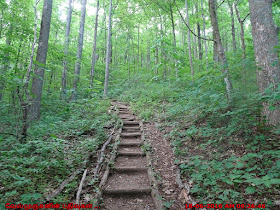
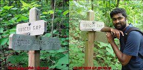
Unicoi Gap, Hike the Appalachian Trail from Unicoi Gap, climbing to summit views at Rocky Mountain and Tray Mountain and through lush forest filled with wildflowers and mountain laurel.
Appalachian Trail Unicoi Gap
Appalachian Trail View Points Georgia
Georgia Trails - Unicoi Gap Trail
Indian Grave Gap Trail
As part of its northbound, 2000+ mile hike from Springer Mountain to Maine, the Appalachian Trail treks some of North Georgia’s most beautiful terrain. This ten-mile roundtrip on the AT scales to some stunning views from two mountain summits, Rocky Mountain and Tray Mountain. It crosses trickling creeks, climbs through mossy, boulder-filled forest and tunnels through gnarled, low-canopy forests filled with mountain laurel and wildflowers. And along the way, the hike crosses through some abundantly beautiful, lush Georgia forest.
North Georgia Mountain Wilderness
Tray Mountain Trail in Georgia
Rocky Mountain Summit
Rocky Mountain Trail
Chattahoochee National Forest - Georgia Trails

The hike departs from Unicoi Gap, one of a few paved trailheads on Georgia’s 75-mile stretch of the Appalachian Trail. It’s a great workout, climbing and descending a combined 6600 feet over its ten-mile journey to Rocky Mountain, Indian Grave Gap, Tray Mountain and back. It’s by far one of our favorite stretches of the Appalachian Trail in Georgia, and it’s an equally great, challenging day hike as it is a quick overnight backpacking trip.